WEATHER MADE CLEAR FOR ALL TO HEAR

"But seeing they could not See; hearing they could not Hear"
“The views expressed herein are those of the author and do not necessarily represent those of the National Weather Service or affiliate/related organizations. Please consult .gov sites for official information”

"From its chamber comes the whirlwind, and cold from the scattering winds." - Job 37:9.

"The wind blows to the south and turns to the north; round and round it goes, ever returning on its course".

Friday, August 17, 2012

Twist of Fate Day Explained, Strong/Severe Warned Possible

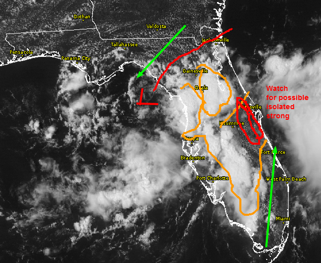
Activity over Gulf Could send an Outflow Boundary out across North Half of State Too Early
TODAY: "Twist of Fate' Meaning a twist to the day's forecast contingent upon what occurs with that large storm cluster off shore in the Gulf. If outflow occurs and blows across the North Half, then storms might try to initiate to early before the east coast sea breeze has a grasp on the situation and before instability can build up. That possibility at this time is indeterminable and even so might not make that much of a difference, only to prevent stronger activity there. Strongest activity well could be further south though from Central Osceola toward South Brevard and southward toward Lake Okeechobee toward West Palm, but not anyone appears to be immune to impossibles. Even earlier activity could form near the Cape as soon as the sea breeze starts by 2pm.

Otherwise, cool temperatures aloft are again forecast in the mid-levels across Central although some guidance paints the entire state being cooler at those levels. With no inhibition and ample moisture, that also means an early start (somewhere). 

It does appear a 'boundary' is in the making from Bradenton to south Central Brevard and suspect some tricky mis-guided doings and surprises are in today's package of tricks along those lines especially toward the east coast.  Earlier activity less strong, stronger activity after 4pm per yesterday's chain of limited events except toward East Central. Steering is also stronger toward the east all regions and earlier activity will only enhance the effects from outflows toward the coast, strongest north of West Palm by a few miles per hour, thus activity should not dawdle as much as yesterday along the Indian River of Brevard and south, lingering longer South Central to parts of Southern portions.

It would be pertinent to be aware of activity AS it forms today, as the first bolts oft occur outside of the rain area, or when it is barely raining. This holds true for beach goers as well. If you hear thunder, it's best to make head way away to safe shelter, meaning the inside of a building. If one does not hear thunder but sees towering clouds, same holds true even more so!... leapin' 'lizards' know no bounds...by miles even, zap.

BEYOND: No change from previous post, day by day basis analysis for showers and thunder possible through the weekend and at least into early next week. .

No comments:

Thursday, August 16, 2012

Similar To Yesterday, Same Through Saturday

The only difference today is temperature aloft might be a bit cooler in the red zone east central, otherwise, the wind patterns have changed very little. The rest is up to chance
TODAY: Not much different than yesterday, same holds for the weekend. Upper level trough to deepen with the core low well toward the Great Lakes if not Canada. As it 'deepens' (or pressures fall) so too will the trough over the eastern 1/3 of the U.S.  which could increase steering toward the east coast (mainly northern 2/3rd of state) a bit more by the weekend. Otherwise, deep moisture with drying in the mid levels, cool temps aloft that are less than otherwise   a full bore tropical environment, could lead to some stronger storms with heavy rainfall mainly beginning after 5pm through dark if not later contingent upon remaining out flow boundaries and unadulterated, energized areas awaiting to activate.

Activity most likely to work off the east coast from North Brevard on up, but propagation from those  storms could result in enhanced activity further south to work both east and to the south and move off shore as far south as almost Vero or so, if those areas are not too worked over  early on or are encompassed by high level cirrus from earlier activity. Once it is dark, it becomes irrelevant as lifted condensations levels will be then be lower making it easier for storms to self-sustain a bit longer..and move faster on their own accord by self propagation within their own storm mechanism structure. Would not be surprised to see some severe warnings and reports today, or bordering toward that due to winds...maybe pea hail to smaller than that.

BEYOND: Continued storm chances each and every day with heavy rainfall and gusty winds in and near the storms, especially toward evening. We received here 1.80" of rain in a relatively short time frame after dark last night, with powerful CG lightning mainly off shore as the storms regenerated yet even still. Some gust winds were realized as well, knocking pool furniture into the pool.

No comments:

Tuesday, August 14, 2012

The Summer Games are On and Unchanging, Win!

Monday, August 13th at a Cape Canaveral Manatee and Exercise Part
Dot...dot...dot.

Possible Stronger Storms Today in Red Zone for Starters, One Severe Warning Just Issued near Tampa at 3:40pm
TODAY: Not much to say really, if you know what yesterday was like you're good through Friday with minor variations to the same theme. I hear thunder as of this typing, but there's no rain (here), at least not yet. Highest instability appears to be across Central with activity already having begun. Steering is light from west to east about 8-12 mph, and sea breeze collision has yet to occur. 

Therefore, with late day enhancements adorning the low level wind pattern as   the sea breezes meet  with additional outflows from earlier activity, could see some strong storms continue yet very isolated into early evening. I really did not spend too terribly much time going into high refinement mode as this pretty much sums it up in the absence of strong winds aloft, extraordinarily cold air aloft not so much, and lack of synoptic scale boundaries as it appears providing for standard Summer 2012 fare, "It" has finally arrived (although one might have thought so along time ago, in a sense, the storm patterns never really did). Let the games begin..


Wednesday through Friday?   dot..dot..dot...


No comments:

Wednesday, August 8, 2012

Transition day -Showers/Storms Possible Mainly North Half

Remnant hint of mid-level trough near edge of bounds of high pressure shows in the band of gray across Central which started out as greater cloud coverage early today could play in  later on.
TODAY: Transition day. Transition from what? Hurricane/Storm Ernesto has made landfall and has thus moved far enough from Florida to stop effecting the mid-upper level pressure pattern. As a result, although steering is weak, from near the Cape and north it is from the west to northwest, whereas below that they winds are negligent. Precipitable water values are remnant from the Tropical Wave over the weekend and have been lingering in the region for days now, but the greatest concentration is north half as further south, this region is indirectly being sucked dry by Ernesto. Guidance shows a deep moisture surge along the SE Florida coast but satellite imagery does not reflect this to be the case, at least not yet. Therefore, with sea breeze convergence closer toward the West Coast and latest guidance reflecting some cooler air aloft could mean either storms could form for one reason or the other SW of Lake Okeechobee with some colder air aloft sneaking in. 

The better likelihood is to the north though. With the storm pulling away in a near COL pattern over Central and South Florida the mid-level trough further north is now permitted to work south more during the day to some degree between meeting the eastern Atlantic ridge axis barely reaching across Central Florida in the lower portions of the mid-levels toward Central.

With that said, steering is from the west to even NW later today toward East Central. Chances are any rain will remain west of I-95 South of I-4 but it is not guaranteed. It could be the zone south of I-4 will see increased mid-level clouds later today and that will be that, with the better chance of possibly even offshore moving showers and thunder from Central or North Volusia and west (and north of there). There is a bit of a dry mid-level slot across South Central which might have thrown earlier model runs off, because they are no longer showing storms NW of the Big Lake as was the case earlier. That, will only be determined later today, but for now have left that region out in the rain coloring schematic.

TOMORROW: Some general pattern continues with better chances of rain (but barely) from SW Florida NEward toward I-4 and north Florida with other showers elsewhere, although the immediate coast south of I-4 is in question, but likely a no-go for rain at this conjecture.

WORKING TOWARD THE WEEKEND: Appears moisture from a few tropically undefined by name or status 'wave like perturbances'  could be working toward Florida with a shift toward a more Southerly to SSE in the low levels to SW steering and overall wind direction ensuing, albeit light. This would mean an increasing in afternoon shower and thunderstorm activity from a broader perspective, with activity hedging toward the east coast and potentially cloud lines and showers setting up along to just west of the east coast intracoastal waterways. Warm and muggy as would be expected.

TROPICALLY BEYOND: The GFS has been showing except in one out of four daily runs for two solid days a hurricane approaching the U.S. east coast toward the third week of August. This is quite far out in time though, and could suddenly disappear at the drop of a dime. The EURO does not even go that far out in time for clarification purposes on any actually threat which has varied with a margin of error, or cone of error, that extends from the Florida east coast to just off Maine. The pretty much covers the bases and says essentially nothing..but for now, just an itch behind the ear. Might not hurt to look in the pantry and buckle up on storm preparations though since we are approaching the Peak of Storm Season going from Late August through September and into early October. Nothing like being caught with the pants down and nothing to buckle up with before the thundering throngs crash the market places and the price grouches  (gougers) play their pawn for check-mate at the counters.

No comments:

Saturday, August 4, 2012

Chances of Rain/Thunder Much Later Today/Tonight with Wave?

Storm Prediction Center mesoscale analysis extracted from the Rapid Refresh/RUC shows the surface based axis of the Tropical Wave has entered South Florida and tilting toward the NE. The mid-level
axis is a bit further back to the east (barely) . PROBLEM, the axis in the mid-levels is dry with the bulk of the moisture well behind it and along the northern 'crest of the wave'
TODAY: Winds at Canaveral have actually gone N-NNE in some locations per surface observations. Prime indicator that East Central is still ahead of the tropical wave - wind shift line  axis at the low levels. It appears the greatest moisture in the mid-levels needed to make rain resides yet further back than this surface wind shift line with a dry slot apparent as of the latest guidance. The dry slot could take nearly all day to clear the coast and shift inland, but per some guidance will throw in as shown below the rain chances later today toward late afternoon and into the evening. The NAM continues to show a tiny vorticity center in the mid-levels as is shown above moving directly over the Cape Canaveral/Titsuville area and then continuing toward Ocala then into the Big Bend heading into Sunday.  Meanwhile, with the dry slot, very muggy with possible showers mainly west of the river intracoastals but more and most likely near the first area where moisture increases and along sea breeze boundaries toward the SW Coast and interior. Best rain chances eventually could well be near and north of the vorticity lobe where coastal convergence will be maximized due to slightly stronger low-mid level winds (but nothing significant in the wind regard).

SW Coast region with inland showers possible about anywhere most likely much later (if at all) toward the East Coast from Brevard County and North . Again though, this is a mere rough guesstimate so as always consult the Official Forecast from the National Weather Surface.  We may eventually be hearing about the chance of waterspouts come late today or tonight from any strong, onshore rolling shower  or storm, but again the time (if ever) is questionable in regard to rainfall chances
  TONIGHT: NAM is consistent with bringing this vorticity center shown into coastal Central Florida with the surface reflection of a weak low level circulation over South Florida, The entire trough moves WNW over night with greater moisture continuing from what is currently in place on Sunday behind it being dragged behind on its tail flank. It is noted that temperatures aloft are much warmer now, or are forecast to warm, thus thunder might be hard to come by heading into Sunday.  It could well be that any rain showers with cool winds will stabilize large areas right from the get go, and with such slow movement of shower activity it might be that widespread coverage at one  time will be hard to come by if ever. This is more of a 'different slant of the story' from the main broadcast weather headlines possibly been heard elsewhere.


Meanwhile, Storm Ernesto is moving West into the Caribbean as we read and speak. The official guidance can be seen on the future track on any channel. Interestingly, the GFS shows the track to move a little toward   the south, and the latest guidance on CIMMS shows the Deep Layer Mean flow for this 'less than well organized system' could take it in a more WSW direction for quite some time by later today and into tonight, into Southern regions of the Yucatan or a bit further north. Based on those tid bits of  (model data) information as well as the Euro which last I looked took it practically into Central America the concerns for other than Jamaica are as of right now not too high, at least not in regard to Florida's perspective.  


Locally, rain chances look questionable to me through Monday, with both locations and timing of rainfall a tough call. With warm air aloft, any rain cooled air regions will have a tough time manifesting much of anything more due to limited instability as cloud cover increases. We'll just have to see how it all plays out. Could end up being a mainly nocturnal event from start to finish near the east coast and eventually a broader area heading into Monday.

No comments:

Friday, August 3, 2012

Interior Strong Thunder Possible, Muggy Messy Weekend

Green shows rain chance zones heading into red, where isolated strong storms are possible due to mid level dry slot preceding a tropical wave (much like a dip before an ocean wave) and cold air aloft along the Lake , east coast sea breeze, and west coast sea breeze meeting places
TODAY: Will not go into extraneously extensive detail as guidance continues to attempt a resolve to what could occur this weekend in regard to a tropical wave and timing of it being realized up the east coast.


In the next image a general idea can be seen of what is going on out and up there this morning. The mid-level trough of the past several days as expected is lifting out as a tropical wave moves in from the SE to replace it. The moisture field associated with the wave is deep, up to 10,000 ft at least, but preceding it is a dry slot in the mid levels although the lower levels remain quite moist as can be felt upon stepping outside. Cold air aloft remains though, so between the colder air, instability, and Lake and Sea breezes coupled with outflow boundaries from showers and eventually storms the saga of rain and showers today could continue well past dark over the interior and toward the west coast as steering is shifting now toward the interior and west side from  the south- south -east to north during the course of the day.

This is for 10,000 feet, with the darkest green being the greatest moisture at that level. It is also deep to the surface in these same locations below in the lower levels of the atmosphere. Note the dry slot though of white. The area WNW-NW toward interior Volusia could see some good rains and west of there, as steering is slow, thus, some big rainfall totals could be realized somewhere today by the time mid-evening comes
Tropical wave seen above over the Bahamas. Without going into great detail there is two options becoming apparent per the NAM and ECMWF. 850mb vorticity (center) is shown consistently to approach Brevard County on Saturday with a closed mid -level low working downward toward the surface but circulation is weak. With cooler air aloft,  for even in rainshowers over the weekend (particularly the first one of the day for any location) winds could be strong in and near them, but once an area is worked over by rain cooled air, that is no longer much of a factor except near the vort max.  The NAM goes too far likely, showing nearly a 'dry eye' center near South Central Brevard by Sunday with rain all around it but not heavy. Point being, winds across the Bahamas may generate a self-induced weak surface low just as westerly winds downstream of the Rocky Mountains create a downstream trough over Kansas and Oklahoma. Timing will become factorless on the rain chances but best chances will be mid-morning through mid-evening Saturday and Sunday, with the greatest chances of rain over the weekend commencing within 3 hours of sunrise and working west across the state. Cloudy and muggy mainly on Saturday and into Sunday, keeping the highs in to the mid 80s on average, but warmer depending on when it rains elsewhere and when or the extent of cloud cover. Winds from the SE by then going into Sunday behind the wave with moisture continuing.

On the other-hand, the GFS refuses to give creedance to any low pressure development by all means, but does imply a mid-level vort lobe. Either way, best rain chances appears over the weekend with partly to mostly cloudy skies, and humid and muggy 24/7.


BEYOND: Continued backwash moisture into Monday, with perhaps another 'wave' of moisture moving in well north of the other tropical disturbance, the 'storm', passing well south of Florida. The extent to which that system wraps up will determine our outcome into mid week weatherwise. The less wrapped up it is, the better chances of rain here will be.  

No comments:

Thursday, August 2, 2012

Isolated Strong Storms Seem More Likely Today, Mainly Beyond 4:30pm

Lighter steering toward the east (slower storm motions) will allow sea breeze and Lake Breeze boundaries to interact today. Overall, steering toward the coast seems more likely from Palm Beach County and north toward Southern Volusia as the 500mb trough is now located from near St. Augustine to Port Charlotte, and vorticity is stretched from near Bradenton to Cocoa Beach along its leading edge most of today
TODAY: Another variation of the past two with again a cluster of storms in the NE Gulf and what appears to be an outflow boundary if not now but soon to develop which could accelerate  from the west coast sea breeze inland across all of North Central except closer toward 528.  Thus, activity 'might' get started sooner here away from the upper level energy, although some mid-level energy could be realized for a stronger storm due to winds. Chances are though, the better chances for said strong activity will reside from near Port Canaveral southward toward Ft Pierce (in particular)..or perhaps Vero to Southern Palm Bay as a result if interactions with the Lake Breeze and sea breeze and resultant domino progression both north and southward.


The sea breeze, although light, could make it toward I-95 before realizing the west coast breeze south of the Space Center where steering further south ahead of the upper level trough will be more favorable for off shore or off the coast storms to result, as well as outflows from them reaching back to the coast to trigger more activity in 'a location somewhere' within those bounds from Brevard and Southward to Miami in general.


Temperatures aloft are cooler or are forecast to be so today than the past two days, so gusty winds and frequent cloud to ground lightning is entirely plausible to assume will or can become a reality as well as dry air 'head bolts' preceding actual rainfall occur. Thus, be T'wise to take extra precaution both inland where clouds developed toward Orlando and South through Eastern Osceola County to the Lake Shore of Okeechobee. Would not be surprised if a funnel cloud or so report came in for entertainment purposes.


FRIDAY: Tough call frankly, as a tropical wave now over Central Cuba and northward will begin to lift the ridge axis now over far South Florida northward messing with our steering currents as a result. More than likely activity will not be impacting the east coast directly (i.e., beaches) but rather along and west of the intracoastal and the interior.


WEEKEND: Moisture associated with the waves to wash ashore sometime Saturday afternoon or evening toward early Sunday, hard call, but soonest along the east coast south of West Palm on Saturday. The ECMWF has been consistent with an 850mb vorticity center to clip just near the east coast, closest from Vero and the Cape ,so it is probably not safe to make any assumptions on timing and extent of precipitation heading from Late Saturday toward Sunday morning at this conjuncture.  


BEYOND: Moisture could loiter through Monday into Tuesday with likely a few tricks up its sleeve concerning time and location of rain and/or storms.  
Otherwise, there could be a  drying trend heading into mid-late week as the now Tropical Depression in the SE Caribbean slides mainly Westward south of Cuba and potentially close to Jamaica taking in the moisture field and robbing it from Florida. Guidance does show the system to become named or nearly so  , but it is tough call as to exactly when. Most guidance shows the system to become 'fully mature' to whatever extent that means near the Yucatan, taking it into Mexico or Southern Texas in about a week. A few outliers desire to drift it further north however. Point being, that's the point. No one can say, as is always the case is the extended absurdness. Such was the case last month or was it June when I system was though to head toward Texas and ended up around Florida. 

No comments:

Tuesday, July 31, 2012

Variation of Monday in Progress - Showers and Some Thunder Possible

Thick Lipped Arcus Cloud/Storm Gust Front over Canaveral Warehouse
ANOTHER DAY OF 'DOMINO CHAIN REACTIONS' AND POCKETS
OF DRY AIR GUARANTEES  "NO GUARANTEES". Example chances of storms and perhaps something stronger in red but best chances of thunder in the green bounds (although far South Florida could see a very strong storm in no--man's land
TODAY: Different version of the same thing of what occurred yesterday is at hand. From image above, it can been seen a large MCS (Mesoscale Convective System) has dropped across the Panhandle already earlier than yesterday and the west coast sea breeze in broken zig zag fashion has initiated, all the while a line of showers is forming across North Central. This is similar to what occurred yesterday, but the MCS is much bigger and earlier than yesterday's event. Other wise, the east coast sea breeze has too set up south of Daytona.


Thus, we have outflow from the initial MCS, both sea breezes, and Lake Breezes to contend with in an afternoon that is not exactly atmospherically filled with abundant but nonetheless ample enough moisture where mechanisms meet. Additionally, chances are that activity along the North Central line could send off an additional outflow boundary south and east , thus some areas might circumvent rain altogether across Central with the exception being, or rather, the mitigating factor being rain cooled outflow and enhanced clouds over-passing some areas instead of rain. Exactly where across North Central into Central the outflow(s) will cease will determine who will receive the next shot at rain and storms heading toward 4:30-6:00pm. The region from South Brevard to the eastern shores of Lake Okeechobee so far look more favorable today as opposed to further north with the exception of the Titusville region once again toward Port St. John. Steering toward the NE looks a bit stronger today as outflows work south but really anywhere from Southern Volusia to Ft Pierce have a chance for a storm with some stronger gusty winds.  The other area to watch will be toward the Everglades and eastward into perhaps parts of Palm Beach and Martin County (otherwise).


WEDNESDAY: Looks like yet again day 3 of the escapades cycle similar to today and yesterday, with the exception of the unknown storms to the north forming which have been the catalyst for the forecast further south this week in regard to stronger activity. There is a chance again of activity tomorrow, but exactly where and why will be the question, same with Thursday.


BEYOND: Tropical wave could affect all parts of South Florida on Saturday toward the Cape but the bigger impact looks to be statewide starting early Sunday working toward the west side by late afternoon, after which point we could be in for a complete change in the weather pattern and an end to east side thunder. This is a recent 'future-cast development' though, so at this point looks best to take it as it comes.


In regard to tropical activity, nothing big showing up in guidance (yet) other than that there is a noted area in the mid-South Atlantic which could end up crossing the Yucatan, but at this point pure speculation. Guidance nowhere is showing anything strong to form, but more could be on the way. We should be entering a more active tropical period though in the coming days as we enter August, although 'more active' is relative to what we have now which was close to zip. Guidance shows more energy coming off Africa, but nothing close to home. This too though, changes off and on , but no true 'threats' worth noting are being speculated even out to 10 days.

Camera lens fogs up with moisture locked inside due to humidity level changes taking from a cool inside place to warm moist outside place. Cape Canaveral on Monday afternoon.

No comments:

Monday, July 30, 2012

Thunderstorms Occurring Now and into Early Evening

12:45pm Radar and lightning depictions are showing lightning strikes with all activity over the Northern 1/3 of the state. Sea breeze related activity has yet to get started. Drier air now in place across Central will be the make or break question later today as outflows and boundaries from the north could 'dynamically' provide the necessary last ingredient for some stronger storms toward Brevard and Martin/St Lucie/or Indian River County near the Lake/Sea Breeze boundary
TODAY: Continuing to play hopscotch with the fickle mid-level trough and now surface boundary across North Florida with the 700mb trough shown (and forecast to) inch just a bit further South and East today providing for better steering toward the east to Northeast. The factor toward Southern Volusia outside of the predominant steering is whether outflows from current activity will work toward the slightly drier air Central and meet up with the sea breeze front which appears will stick very close to the east coast today east of I-95 or near it.  The situation   raises an eye-brow of contentious curiosity but nothing definitive toward the red areas (namely Brevard), but the most likely of the three appears to be the Everglades area. Areas of rain showers are also possible anywhere but very isolated, as is thunder other than that shown in orange (but very isolated). Coverage looks extensive currently though, and mass amounts of rain cooled air could sink southward from where the current activity exists with no problem for activity to spark continuously southward through late afternoon. The question mark being what happens when drier air is reached? Will it mix out or add fuel?


TUESDAY/WEDNESDAY: The 700mb trough should begin to weaken, as such so does steering as we resume a pattern not unlike the past several days, running the 'day by day basis' of the when and where game once again, but isolated. Most assuredly North Florida though as the moisture ribbon works toward Central appears to be the most likely zone, thinning out along the way.


Radar superimposed with the 700mb (10,000 foot above ground level) features shows dry air all of Central South 
MEANWHILE: The ECMWF model shows at least two disturbances (and has been for two days) to roll westward along the Southern Atlantic, first toward the Puerto Rico region toward Florida but that 'track' of this wave changes. The more pronounced item is still further to the east yet still half way to Africa at least. One shown to stay south, with the later shown to curve more WNW-NW with time in the general direction of the SE U.S. We should be hearing about both of these for the next week to 10 tens (and possibly yet another) in some form or another, with a 'storm name' possibly emerging in the next 4-7 days. 

No comments:

Saturday, July 28, 2012

Same Old Story, Different Hat

Same old story - "It might rain here or there but not everywhere. But where is anywhere? Somewhere"

No comments:

Friday, July 27, 2012

Chance of Isolated Thunder after 4:30pm (Until?)

Moisture from SW Florida where showers now reside should be able to snake its way north and east a bit through early evening in the lower 8000 ft with self-manifested by earlier showers themselves moisture higher up along the sea breeze convergence boundary Eastern toward Central interior by late afternoon. The west coast sea breeze is already pressing eastward as of noon time in a broken uneven fashion so timing will be critical factor today in regard to how, where, why, and when any storm (s) will or can manifest 
TODAY: Beyond the mud, the 700MB circulation manifested yesterday as an MCV (Mesoscale convective vortex) over the Northeast Gulf has opened up, and appears to be getting slightly nudge eastward as a result of temporary troughing further north as a result of a front that pressed through the Northeast States yesterday.


At the surface, the low level ridge axis remains across Far South Florida with low level moisture feeding around its stronger western periphery along the SW Coast and as per guidance will be pressing NE ward during the day. Latest analysis is showing sufficient moisture in place from SW Florida to North Brevard in the lower levels, but  above those twoard 10,000 feet it is quite dry in all locations except in the western Panhandle. The west coast sea breeze has already begun and seems to be taking off eastward faster than would be normally expected, perhaps due to the 700mb trough actually pressing east just a bit. In any case, beyond that mere speculation the greatest instability today is unevenly dispersed with the only consistency being just along the Atlantic Coast. Chances are, more low level moisture, hence atmospheric buoyancy will be lifted North and East as sea breeze circulations meet and squeeze moisture NE ward along the 850-700mb flow.


With those rough and sketchy depictions showing on models, some thunderstorms and showers should be spreading NE ward from the South as the afternoon progresses with an isolated shower or storm possible toward Western or Central Volusia, although that one is the big question. What seems a tad more certain is thunder and showers working as far north as I-4 in the Orlando Area and eastward toward the Eastern Osceola County area and possibly showers and thunder almost as far east as the Sanford into the Mims or even Titusville area by 6 or 7pm. This all being the 'worst case' scenario for those not wanting their picnic rained on.  


The graphic shows one general area where a stronger storm could exist due to down draft winds..a result of the dry upper levels cooling upon decent into the more moist air in thunder or even heavy rainstorm down drafts. Temperatures aloft are not all that cold, but any storm (if there be one) that punches through the dry layer on its own devices along converging low level wind fields  could put on a spectacle, then back trace southward beyond dark into Osceola County. "Could" being the operative word in all cases. The final 'could' or 'might' is thunder after dark south of Orlando. As noted earlier, all of the above depends upon when the sea breezes meet. If it is too early, all bets are off.


BEYOND: Saturday looks a bit like a variation of today with Sunday through Tuesday going up and down on the rains chances near these same locations as time will tell.


WEDNESDAY: As would be expected, it is summer and the dry air cannot last forever over Florida (one hopes).  Moisture only increases or varies in small increments from day to day into Wednesday but from there on out the GFS and the latest ECMWF (Euro) indicate a tropical wave to cross near Puerto Rico and arc NW toward Florida (previously the ECMWF was showing a possible depression but is now amazingly close to the GFS, which given that is a good 5 days away is sure to change several times if only over the weekend).


 In any case, per what is given today, increasing rain chances Wednesday but much more so toward NEXT weekend for a few days with two moisture surges.

No comments:

Wednesday, July 25, 2012

Warm and Hazy South, Variation of Yesterday Elsewhere

 Taking the camera from A/C to warm humidity late yesterday to capture an image resulted in 'moisture on the lens'. This Cape Canaveral , Florida Arcus Cloud trended toward being a Shelf Cloud due to the close proximity of the actual rain field, meaning little time for outflow separation. Rain field seen bottom right corner of image. Thunder boomed with lightning very near by at this time.

Radar image from Tuesday is interesting. Note how activity hit the sea breeze over the Banana River and quickly 'jacked up' per yellow through red actuals (not drawn in). Most lightning was toward the Industrial Area and the Pads out at the Space Center

TODAY: Somewhat a variation of yesterday mainly north of the Pineda Cswy in Brevard County west toward the South end of Tampa Bay.  The better chance of storms, some quite strong to marginally severe along I-10 and other zones in the Panhandle toward Tallahassee and a bit east of there.


Further South, trough in the mid-levels dropped south just a bit from yesterday but is slowly loosing identity. The axis extends currently along to just south of I-10 but could drop as far south as the Beach Line by 5pm. Guidance is trending that way at least on the short term RAP model, and the GFS from 2AM seems to be hedging in that direction since the 2PM run yesterday. Based on the latest Analysis a good west coast sea breeze appears to be in the making dynamically speaking which would fuse eastward fairly rapidly not unlike yesterday, with the southern end lagging a bit toward North Brevard or even Central Brevard. For now for that entire zone, showers mid-day might be more in the making toward the interior but tough call regarding the thunder here (interior) due to the unfavorable time of day during peak heating when lifted condensation levels are 'normally' a bit 'elevated' as is the level of free convection. On the other hand, with the latter time of the day being preferred the further east one looks, the I-95 to US 1 corridor could be the better breeding grounds for thunder with low level forcing created by the coast hugging sea breeze. For now, It appears it will make little lee way beyond US1 up and down the coast.  Showers and any thunder will roll off the coast uninhibited, with a "Tail End Charlie"  storm possible near the Space Center toward Port St. John,  Port Canaveral and Titusville area across the Merritt Island Wildlife Refuge. It is tempting to draw that zone a bit further north though, as short range guidance waves up and down north and south. In short, it appears it will all come down to timing issues so there is no point in musing further.  Further south, showers and maybe a rumble are possible to Sebastian in quick passage.


SOUTH FLORIDA: Haze appears to have moved in based on satellite imagery and moisture at all levels necessary for storm formation appears to be sorely lacking. However, the forecast office down that way and another office are watching the Lake Okeechobee area toward Ft Pierce to West Palm once again (where some strong to severe wind reports came in yesterday in that county).

BEYOND: Dry air from the North and South closes in as rain chances dwindle to negligible to down right zero  in an unusually dry pattern atmospherically speaking for this time of year except far North Florida toward possibly Flagler County. Moisture rejuvenation begins Sunday toward SW Florida working North and east into Monday when storms could form into Central Osceola County toward Brevard, but further North seems to be getting the dry side of the coin. 


Better rain chances yet still though Tuesday before Wednesday where better coverage in the 40% forecast range might be getting closer to home for most forecast offices..

No comments:

Tuesday, July 24, 2012

Strong Wind Gusts/ Lightning Possible Near Beaches in Any Storm

Arcus Cloud or sometimes referred to as a  'Gust Front'  from Leading Edge of Rain Cooled air mixing with the sea-breeze (above) at Cape Canaveral on Monday. This 'front' extended well to the South and north as well

TODAY: Mid-level low is positioned over the NE Gulf and appears will drop southward just a bit during the day before eventually eroding through Wednesday. Meanwhile, low and mid level ridge axis is across South Florida . Between the two a general WSW-SW flow is at hand as expected with a shallow sea breeze having penetrated coastal communities from Miami to at least as far north as Cape Canaveral running up toward the Industrial Area on the Space Center. An area of showers that was over the waters off the coast of the Big Bend and south appears to have collapsed and sent an outflow boundary of rain cooled air eastward and is now manifesting as a line of showers and some thunder as well. Strong activity does not appear for the most part to be at play with this activity.


Further south from near The KSC along the east coast is a different atmospheric story where mid-level dry air (especially south of Melbourne) but respectable low level moisture is generating some storm activity along the Lake Breeze and near shore waters, seemingly as a result of outflow from an offshore cluster for storms early on.


In summation, prevailing SW steering to meet the sea breeze very close to the coast in an environment suitable for an isolated storm or two containing some wicked lightning and brief strong winds, but this activity might for the most part move rapidly offshore after developing if it does at all. Stronger activity, IF there is any are noted in red as a starting but not all inclusive example, especially after 5pm. Weather permitting.

Image showering rain-cooled outflow near Big Bend by dashed yellow. In orange any thunder will be very isolated, but as boundaries interact there could be momentary but brief increases in lightning or coverage during the afternoon.
Enhanced Progression of the west coast sea breeze from the outflow puts activity south of SR528 a bit later in the day than further north with a chance of a 'freak interaction'  somewhere from Port Canaveral, Port St. John, Titusville, Launch Pads zone if not a bit further south.  Already activity in place further south with boundaries to approach far South Brevard and the general West Palm area. Any activity near Miami and south if it can manifest could be strong, but this area might clear out too soon with the west and east coast sea breeze meeting too early on in the day.

"Arcus Cloud" Some Might Call This, Other's A Gust Front (non-technical term). Port Canaveral on Monday. "Shelf cloud" would technically be incorrect.
BEYOND: Much drier air to below seasonal norms over the Florida peninsula through the mid-levels with warmer than normal east coastal and east side of the state temperatures to prevail with delayed sea breezes each day, or perhaps none at all Wednesday and/or Thursday. Chances are though, the zones along US1 toward A1A will find the relief by noon time or so with inland zones not catching a break.  Any rain or storm activity (isolated at best) will require late afternoon to early evening sea breeze convergence to even materialize except along I-10 which will occur closer to the east coast than usual. This appears will remain the case through the weekend at the rate we are reading now.
Through The Lens under the whale's mouth of a Florida East coast thunderstorm

No comments:

Monday, July 23, 2012

'Possible' Strong/Very Strong (Isolated) East Central)


Quick post today due to time factor . Area of showers and thunder is approaching The Center of the state in the midst of on-going activity as noted above. The area in South Central is moving NE-ENE and heading toward a CAPE gradient boundary aligned from near and east of Kissimmee or mostly the entire east half of Osceola County, Eastern Orange, and Seminole with a direction poised toward the coast where instability drops off due to earlier cloud cover. Models were in zero agreement today for the most part as a low in the NE Gulf almost down to the surface moves little (appears that way). Mid-level winds are from the SW-WSW over-riding low level SE winds right in the high CAPE zone, so a sudden eruption "Could" occur in the western most red zone in the next 90 minutes or so. Much will depend on if the activity collapses or loses upper level support, as it seems to be getting triggered by something aloft such as a vorticity lobe not shown in guidance. Thus, areas from  mostly of Orange, Seminole. Osceola Brevard, and parts of Volusia might need to have a heads up alert in the next two hours or so. If the area holds up, might need a renegade warning or two..OR..it fizzles to mere rainshowers.


TUESDAY: So far, good consistency up to now for an interesting day taking shape mainly for the East 1/2 of South Central from Melbourne down to Ft Pierce including the Vero area mid-late afternoon.


BEYOND: Much drier, most activity along I-10. Also, much warmer at the coast before the sea breeze, possibly hazy with an isolated late day or early evening sea breeze collision type "something or other storm" near or east of I-95. Low rain chances into the weekend .

No comments:

Sunday, July 22, 2012

Unusually Warm This Morning, Storms and Shower Issue at Hand

Water Vapor Image showing moisture at mostly mid-upper levels.
The more color, the deeper the moisture.
Highlights on animation show what appears to be a vorticity max or upper level low like feature near Lake Okeechobee lifting slowly northward (the red "V"). Ridge axis (blue) to move little today ,if not strengthen in positioning. Note 'speed max' lower right.  
TODAY: Will quickly compare model guidance for reasons that will become apparent further on in this quip. The North American Model (NAM) and short term Rapid Refresh (RAP/RR) are showing zero rain today except along the west coast mainly. On quite the contrary, the GFS is holding fast to several runs prior with deep moisture reaching as far north as the secondary ridge axis shown in the image above by the small blue 'zig zag'  across far Southern Volusia County. It has depicted this scenario consistently, then again, the NAM has depicted the zero rain scenario consistently as well. 


The Storm Prediction Center and the MLB NWS are in agreement closer to the GFS (and possibly the Euro which I do not have access to) which would favor thunder and showers south of the northern most orange line, or mostly from near Melbourne and South across the state. For now, will side with this line of reasoning given the swirl evident near the Big Lake lifting north. It appears the NAM and RAP are looking at warm upper-level temperatures capping off rising motions (as opposed to cold air aloft), thus preventing rain storms and thunder from forming. In short, we are at the mercy of which witch is which, so in playing the 'Wild Card Shrug' will side in agreement although this in my mind is questionable. There is no doubt the west side will see activity later today, it is the east 3/4 of the state that is questionable. When will we know to go from Two Pair and play a potential full house? Apparently not until after noon time when the tables turn and supposedly the cooler air moves in. But better yet, in about an hour or so morning sounding data will be coming in to reveal the true nature of the atmosphere in place over the state 'aloft'. Unfortunately, we still do not know what conditions reside out over the Atlantic and Bahamas (which is upstream for the state in the current flow pattern).

Otherwise, it is very warm prior to sunrise with 80F on the porch and 81F at Melbourne, and warmer readings further South. St Pete is reading 81F with a dewpoint of 80F which is close to morning readings of "insane' on the thermometer/dewpoint scale if there were such a scale to read . Guidance is showing high instability already in place to persist all day long , with values of Convective Available Potential Energy (CAPE) already akin to late afternoon values, unusually so. Not surprisingly then, it is very humid at this hour since CAPE includes the low level moisture (dewpoint) variable from the equation from which the value is derived.
Big Thunder activity north of Cuba moving WNW

Later today, the GFS has been consistent on picking out a mid-to lower level wind speed max rounding the base of the Atlantic High Pressure Bubble (the axis shown by jagged blue above) with the arrows shown in the first image in the lower right toward the state. These winds will advect straight off the north Bahamas toward Central Brevard shortly after sunset, thus there is a chance that some showers or even thunder could move ashore into Brevard after 9pm tonight for a time due helicity curls off the islands. Whether they will make it onshore (as well as the exact positioning of those winds tonight ) will determine if in fact rain is realized toward the Cape Canaveral area.


MONDAY/TUESDAY: Given the already major question, "Exactly where is the best moisture heading this morning?"!   means as well, "Where will it then be early in the week as well?". Point in case, if the GFS is correct , better rain chances most areas on Monday with the offices showing a 60-70% rain chance, whereas the NAM with its output showing ZERO rain chance! :-0  (aghast emoticon exclamation). Will stick with the GFS at this early hour, meaning much better rain chances with thunder Monday. The ridge axis shown in the first image is then to drop South to the south end of Lake Okeechobee overnight Monday night with a flip flop in low level winds and steering currents from WSW or SW toward the ENE-NE. The moisture bubble gets trapped over Central and North Florida resulting in isolated thunderstorms forming mid afternoon through early evening which would be able to move off the east coast north of Ft Pierce or Vero Beach (more likely) while The Far South remains mostly dry.

1 comment:

Saturday, July 21, 2012

Isolated Heavy Rainfall Totals/Gusty Winds In Storms Possible Today

Some stronger storms (red) are possible today with big rainfall totals due to slow storm motion and continues inflow feed from coastal sea breezes accompanied by high instability feed in CAPE and Lifted Indices under dry air in the mid levels
TODAY: Gradually evolving pattern taking shape as expected with the usual twists and turns along the way. "The SAL (Saharan Air Layer) has cleared the area~!!"  pipes the trumpet, "all coasts clear". 


Meanwhile, gradually increasing moisture toward just below seasonal norms except South Florida today will result in more coverage of unsaid yet summer like storm activity as opposed to yesterday's "SW Floridians Only" storms and an isolated pocket near Marion/Lake County (for the most part).  Sea breeze convergence looks like a better bet today with a slant favoring the interior with outflows reaching toward I-95 or US1 very late toward dark. Thus, we could see some increased cloud coverage near the coast, especially north of 528 due to mid-level wind directions pushing cloud debris with no other impacts.


Otherwise, increased low level instability and 'forecast' cooler mid-level temperatures (the morning KSC sounding did not reflect these cooler temperatures, so it is a matter of trusting that they will 'advect' or move into the area in 'red' later today). Above the mid-levels, temperatures are cold enough to support a strong storm or so, if one considers -8C which is well below freezing, cold. A bit hard to imagine   air up there is so cold when it is 90F + at the ground. But, hot air rises, and the colder above that hot air it is, the faster it will rise. That , coupled with moist air which is  more buoyant (like steam), adds up to clouds and updraft columns, visible or not visible to the eye. They are only visible when clouds manifest and in time-lapse, except under a growing cloud base, referred to as 'cloud tags' .  Strongest storms after 5:00pm mainly from near the Osceola County line up toward Orlando / Narcossee (maybe), Kissimmee, and much of Polk County as well as further to the SSW where deeper moisture will advect in as the day wears on.


As this activity collapses under its own weight due to slow storm motions, outflows (quite gusty due to cold air falling) could extend well past the west coast and near I-95 or US1 on the east coast with little effect other than some clouds. With heavy rain, frequent lightning, gusty winds, and BB sized hail potentially in an isolated momentary up-burst collapse well in the interior , the immediate beach-goer will remain ignorant to all this occurring in the   after 6pm while innocently tipping the toes in the cool ocean waters behind one's back to the west while considering a sea shell.  


SUNDAY: Discrepancy being resolved, but still not quite, as models disagree on how far north moisture will get on the east side of the state as opposed to wrapping south of Lake Okeechobee and up the west side. It's looking more like the rain producing qualifiers will remain from Indian River County and South and work toward the inland and west coast area toward Cedar Key or Brooksville, with the rest of the east remaining dry.


MONDAY: The plot thickens. Will the moisture  in a secondary surge slap a an atmospheric moisture wave ashore further north  ...or is it Professor Plum, in the library, with the candlestick ? Implications are the former will be the case, but with thunder activity inland mainly South Central and South, not too far off from today...will have to investigate this with a magnifying glass more as we work toward tonight and Sunday.

No comments:

Friday, July 20, 2012

Remote Chance of a Near Severe Storm Today

"Storm to the West" - 7:30pm Thursday near the Marinas at Port Canaveral

Yesterday a few strong storm  reports came in from activity near Bithlo in Orange County   near Wedgefield and Bithlo and toward the ENE. Much activity that was also likely strong occurred over uninhabited swamp like land, ; one report of small hail also came in. The activity hit the east coast sea breeze west of I95, but managed to progress east toward the coast in North Brevard. Other weaker activity occurred further north earlier near DAB and the Titusville area toward Mims had two shots at rain. A severe report came in that limbs 'the size of a wrist' were broken, but specifics as to whether that was a newborn's wrist or a Sumi Wrestles remains sketchy...the search is on.

 The outflow gust front feature progressed toward Cape Canaveral  and Cocoa Beach.


TODAY: As expected, dry air O-rama in the mid-levels and warm to hot inland in the absence of more clouds and light inland winds. There is not a shortage of low level moisture though with an inversion above ground low enough to preclude formation of big cumulus clouds until later and in-land. SO 'going out a limb' (the size of a wrist) there is a small chance of a storm very late near Lake County as a result of a sea breeze collision which would mount up low level moisture and because low and mid-level lapse rates would be pretty darned strong, it could be near-severe. Any upward momentum that could escalate a storm to the upper levels could end up being fairly impressive but of short life span due to slow storm motion. Any said such event though is highly conditional on other numerous factors.   I see model guidance painting green brush strokes all around Tampa Bay, but given the current tested atmospheric conditions via morning sounding data, would think that either something goes BOOM in a big way, or barely ekes out a drop of rain at all.


SATURDAY: Slightly more coverage of activity tomorrow near I-4 and toward the interior or western interior down to SW Florida and the Glades, as moisture increases and remnant haze clears out.


SUNDAY: Different day entirely. Latest guidance is a bit askew concerning when deeper moisture will work north beyond South Florida. Southerners  might be seeing showers south of the Lake before 10AM if not at sunrise, with activity progressing north through mid morning and early afternoon. Whether or not the immediate east coast north of Indian River County gets wet is even sketchier with model timing differences as big as a full 12 hours. Thus, Sunday afternoon at the beach north of Vero or Ft. Pierce might not be all so bad after-all, with the better chance of rain not arriving until after dark.


MONDAY: Pretty good chances of showers and storms almost state wide with the east side seeing activity with some lightning just about any time beyond 1PM in the afternoon, Hard to say for sure.


BEYOND: Another slot of SAL might come in taking rain chances down to isolated Tuesday through Friday.


No comments:

Thursday, July 19, 2012

Chance of an Isolated Strong Storm Late Today near the Coast

Albeit sketchy at this time of 9AM....
TODAY: As expected, dry and elevated dusty air is moving into South Florida courtesy of Africa. Expect glared skies with filtered hot and humid air there today. Low level moisture is still quite plentiful though, so expect it will be very humid and hot over all of South Florida especially away from the coasts as far north as a line running from Ft. Pierce to Port Charlotte, but some low cumulus clouds will provide temporary respite.  Further north, the ridge axis (of high pressure) is forecast to remain far enough south that chances of quick showers are possible in green. Latest guidance in one model shows storms possible toward the SW coast (however). 


**Side note, yesterday wind gusts were measure in the 40-51mph associated with the storm/storms over North Brevard from Canaveral toward the Barge Canal.


Otherwise, extensive cloud cover is over the North half of the state so not really looking for significant storm activity north of I-4 today. Further south, low level instability as a result of that buoyant low level moist air under the dry mid and upper level air will mount and advect toward Central Florida during the day. At time, higher clouds are streaming across Central from the Northeast, but so far those are expected to dissipate by early-mid afternoon. Those will hold temperatures down a tad, but nonetheless, the invisible instability will be present as the day wears on. 


Winds are expected to become side shore or nearly so from Sebastian Inlet and north up the intra-coastals to a bit more onshore north of Melbourne Beach due to the curvature of the cape.  Steering today remains from the WSW at about 15-20 mph.


Any showers or storms that form north could send outflows south into the more unstable air mass which has less moisture content. Thus,any activity today will require the west coast sea breeze to progress 'silently ' eastward accompanied by those winds and into self created moisture convergence at the low levels along the east side of the state. This convergence along with instability advected north from South Florida and better vertical upward velocities (lifting convective motions) and coastal low level vorticity and some helicity could provide enough lift for a few thunderstorms, possibly strong with wind gusts in the 40-50mph north of SR 528 and South of New Smyrna Beach. Would expect little advance warning of any said potential activity (potential being the operative word), as storms could quickly escalate upward upon cross I-95 give or take a few miles. Winds, if such storm could manifest could outflow toward the Port to Melbourne beach regardless if it rains or not and be briefly gusty as well.


Due note, much of what happens late today is contingent upon dissipation of the high clouds in this same area  colored in the more vibrant color schemes through the north central portion of the state. For now, dispelling the SW coastal area near Ft. Meyers beyond low topped showers. 


FRIDAY: Dry ribbon to lift north to Central with South Florida already beginning to recover. Storms possible the west half of the state south of Lake Okeechobee in general and north Florida.


SATURDAY: Dry ribbon begins to fill in, with what appears will evolve into a chance of isolated activity near I-4 late day and toward the interior as moisture increases from South to North. This , so far, appears will be the better of the two day weekend for outdoor/beach related activities


SUNDAY:  Increasing S-SSE flow to advect a moisture surge northward with showers and thunder working up the coast and interior by late morning, possibly starting out South Florida in the early early day.
Or, perhaps this will be more cloud cover than shower activity. Either way, without much sun or much less of it by noon time or so..not such a great day for the beach appears to be the verdict...at least as of now based on model consistency for 2 solid days.


BEYOND: One more dry time into early next week then the GFS insists now (and has been for a week) for a trough to eventually develop a trough running down the east coast along and east of the Appalachians with the gall to eventually drop a front into Central Florida by late next weekend or so, but given the time of year if even so this were to come to fruition in some form, it might make it toward I-10 or I-4 if this , in fact, evolves at all. Hard to be certain, but any high pressure building south from SE Canada ..opens up all kinds of options in what so far has been an atypical summer nation wide.  

No comments: