WEATHER MADE CLEAR FOR ALL TO HEAR

"But seeing they could not See; hearing they could not Hear"
“The views expressed herein are those of the author and do not necessarily represent those of the National Weather Service or affiliate/related organizations. Please consult .gov sites for official information”

"From its chamber comes the whirlwind, and cold from the scattering winds." - Job 37:9.

"The wind blows to the south and turns to the north; round and round it goes, ever returning on its course".

Saturday, May 25, 2013

Breezy This Afternoon, Drier and Mild Especially Beach Side

According to the NWS a wind surge came in toward Daytona earlier, this surge might reach the beaches of Brevard before noon time and then 'mix out'. Otherwise, very nice weather throughout the weekend and a bit cooler

 NOTE: The GFS (Global Forecast System Numerical Weather Forecasting model) is again bringing back a tropical system toward Florida the first week of June. HOwever, it has been doing this for nearly a week now only off and on in an inconsistent fashion, at this point it holds little to zero credibility although the timing is impeccable.


Delta Launch Last Night As Viewed From Cape Canaveral 

This Severe Warned Storm as it appeared looking west on the 528 West of Canaveral and East of Merritt Island, Florida on Thursday


The Storm Started to take on a
"Flying Eagle" Appearance


No comments:

Thursday, May 23, 2013

"Could" Be a Storm (s), May Be Strong, East Half of State Today

Changes are in the making. After reviewing forecast discussions, morning soundings from early today were not really favorable per them for storms today except toward South Florida, but suspect some changes might be in the making as I write since that time. Water vapor imagery is showing deeper moisture working into North Central which which also reach south Florida later today accompanied by potential outflows from the North If and only if storms manifest toward East Central Florida ..on the other hand....

TODAY: A solid waterspout was noted by the Keys yesterday, as were some funnel clouds reports into Central and South Florida due to the near calm winds throughout the column or depths of the atmosphere (particularly South Florida) . That particular air mass has shifted out but may also be being replaced by one of more continental nature . In short, there is some rapid recycling of the airmass over Florida today best I can tell of a new nature. Morning  soundings might have been taken at just the 'wrong' time to detect the change (hard to say from an amateur's arm chair). Regardless, this would be a heads up post (just in case). 

With that said, chance of some storms, possibly strong moving in from the NW to NNW if not North (in from the coast) working south along the east coast sea breeze later today. Some of these could be strong especially if the can work off shore from near Cape Canaveral and South to South Florida or if one can latch on to the sea breeze front and 'work on it' heading southbound west of US1,.and along the south and east sides of Lake Okeechobee in toward Palm Beach, Martin, and St Lucie Counties.

Activity will end shortly near or after dark most areas.

BEYOND: Things appear at this rate to get   quiet for a while after today for the most part. Easterly wind will ensure in the next days which will also be a bit drier making for slightly cooler east side temperatures and holding more steady over night. Pretty much near normal. It appears this could be the case for the remainder of the month as well.

1 comment:

Sunday, May 12, 2013

Chance of Iso-Strong/Severe Thunder Southeast Quadrant

Severe Warned Storm -Cape Canaveral, Hail in Some Locations Non-Severe,
near Severe Wind Gusts Reported

Above Image superimposed (left) with a severe warned thunderstorm on Saturday. 
AT 447 PM EDT...NATIONAL WEATHER SERVICE METEOROLOGISTS DETECTED A  SEVERE STORM CAPABLE OF PRODUCING DAMAGING WINDS IN EXCESS OF 60 MPH.THIS STORM WAS LOCATED NEAR ROCKLEDGE AND MOVING NE AT 15 MPH.  
  
* OTHER LOCATIONS IN THE WARNING INCLUDE...BUT ARE NOT LIMITED TO...  MERRITT ISLAND..
.COCOA BEACH...CAPE CANAVERAL...JETTY PARK AND PORT   CANAVERAL 


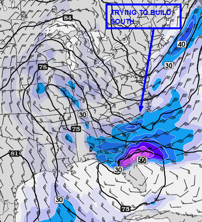
TODAY: Another chance of isolated thunder (iso-thunder) over the SE portions of the state, mainly from near Titusville or Cape Canaveral south to near MIA or FLL (Fort Lauderdale) mostly nearer the east 1/2 of the state.

There are   issues today with down draft CAPE  once again which could limit to some degree large storms, but those same factors (if they get going) could make them popcorn severe. So far, most to all locations near and north of I-4 appear to be completely out of the picture today. The irony is that it is that location where the better wind fields are that would support severe storms, but those to work their way toward the Magical Central Dividing Line running from the Port of Canaveral toward North Tampa Bay. Timing is another issue as well, as outflows, if activity from further south manifest, could advect favorable 'storm air' toward the North Brevard Beaches with an intersect over "Badges Only" no-man's land Space Center. I sent a badge request in last year to gain access to those secure areas but I guess they didn't buy it.

Surface based instability is higher than latest GFS and NAM are showing per the Mesoscale Analysis Page, but lifted index is lacking toward The Beach Line but the trend has been to build that parameter north to MLB or Canaveral. Overall, it's another day of cat and mouse in wonder if , and,, or when the needed parameters will sync together after and during peak heating (number one), and number two, if the east coast sea breeze can get going north of Vero Beach. That is the key ingredient to get the pulse strong storms to activate, at least while they are over land.


Without the sea breeze north of Vero, the stronger storms if any appear will be limited toward Ft. Pierce around the Lake and Southward. In general though, believe the sea breeze will get going around 2pm if not sooner, so should see some showers begin to generate. The models were having problems even up to the latest runs as what appeared to be convective feedback from yesterday's and last nights departing anomaly (which activated storms along the east coast from the Cape and South)  which could have thrown guidance out of whack. In general, the better chances of strong appear to be from near Sebastian Inlet and south at least as of this hour.

Hazards today near the storms would be lightning and wind gusts toward severe limits of 58 mph  with hail the better chance toward Lake Okeechobee and South Florida in general from near Vero Beach south to West Palm and inland a way. Note: The GFS favors most of Brevard, but as of this hour that potential is yet to be seen.  

MONDAY and BEYOND: Chance of thunder again mainly far South Central and South Florida nearer the east coast once again. Outside of Moan-day, a bit cooler and dry (normal for this time of May) at least into next weekend as it appears now. There is a very definite trend the continental U.S. is falling into so far the past 2-3 weeks, all part of the reason why this has been one of the lowest count tornado years in decades.

Interesting side bar is that the GFS is showing a tropical storm or weak hurricane to approach Florida near Memorial Day weekend but take heed, the GFS showed almost the  exact same thing at this time of year, last year.

Manatee Park Madness - Cape Canaveral, Florida

No comments:

Saturday, May 11, 2013

Is there a Chance of Severe Storms Today? Conditional Risk?

RED Indicates to Renegade Remote Chance only as of 11AM Today for an increasing potential for Isolated Strong to Severe Storms today after 3:pm  - 8pm. Heads up post only. 
TODAY: This post for pre-clarification is in lieu of the norm while monitoring a possible unfolding situation so as not to cry wolf. Latest SPC Mesoscale Analysis (next image which is one of many available) is showing some parameters for Supercell Thunderstorms (and even a tornado?) close to the state as a Mesoscale Convective Vortex (that is what it appears to be) approaches the state from the W-WNW. Whether the most volatile parameters conducive for a very active day remain to the west or not is one question, and the next is if they are even valid. In comparing the time scale parameters using the 'back in time' tool, the current values now showing are much further east than previous model runs were depicting. If that trend continues, we might be hearing weather update forecasts coming out after 1pm today, Thus, only a heads up. The secondary option is that there will be a focus toward the East Coast from Daytona and South for storms rolling down the Sea breeze front where max convergence could occur, after 4:30pm or so.

Note the little red box for what this images is showing. In previous guidance plots, that supercell composite parameter noted by the blue traces was well to the west of the state, and the forecast of it was also well to the west of the state, yet, that above is the latest just out.
 Otherwise: It is noted that there is strong downdraft CAPE associated with the unstable parameters which would or could significantly stifle afternoon activity (as was the case yesterday) except over South Florida. Thus, nothing is or might not be as black and white as things might at first seem to be concerning today's forecast.

On one hand, there could be severe storms. On the other hand, if some dry air in the significant layer between the Lifted Condensation Level (LCL) and the Level of Free Convection (LFC) is really like as moisture starved as guidance is showing , there could be very little activity today or what does goes up could quickly wisp out.  BUT, any storm that can get going could be Strong to Severe today. Otherwise, warm and sunny through the morning and early - mid afternoon. Storms , if any otherwise, should occur after 4pm through to after sunset as late as 10pm (as lingering showers and/or cloud cover). Again, worst case forecast for today, a beach and outdoor activities one.

SUNDAY/MONDAY: Once again, a chance of rain showers and thunder on Sunday, more so only on Monday for Far South Florida. Temperatures cooler behind the frontal boundary most notably in the afternoon hours. After Monday, there is almost no chance of rain until at least next weekend or nearly so.

No comments:

Friday, May 10, 2013

Chance of an Isolated Pop Severe Thunder Today, Showers/Thunder through Sunday

Areas in Red are where there is a better potential for a storm to pulse severe briefly, especially north of Lake Okeechobee along the sea breeze and/or Lake Breeze and toward East Central after 5-6pm
TODAY: Early post so much could change, but guidance for the past few hours is fairly consistent so going ahead and sending out an early post to cover that potential for the time being. Convective Instability today (CAPE) is expected to reach between 2500-3000 this afternoon, especially toward East Central by late day. Activity further south might get started before this potential fully develops but breeze boundaries from both coasts could provide ample lower level upward forcing to generate some strong activity there. There was a briefly severe storm down toward Dade County yesterday.  

Further north, east coast sea breeze to get near at least I-95 into Eastern Orange/Osceola County, west of which temperatures could get toward 90F degrees today. The best instability at this early hour is actually moving up the east coast from the south over the ocean. The east coast sea breeze therefore could be potent later today, especially after 5:30pm or so as the Lifted Condensation Levels lower post-peaking heating hours. Air aloft will be quite cold enough for small to near severe sized hail (mainly away from the coasts), but wind gusts could be strong elsewhere in one or two storms all the way to the coast. Thus, we might hear some Special marine warnings being issued.  There would also be a chance for a renegade funnel cloud .  Thing to watch would be any storm that goes up along the sea breeze and works north or south along it, especially if this occurs over or very near the intracoastal just about anywhere. Some activity might eventually either work off the east coast later on in toward evening or upper level winds could spread a cloud deck to the coast for a cloudy sunset.

SATURDAY: Same locations could see a storm but further north as well toward I-4. So far, no sign they will have the potential to be as strong as today , but that could easily change. Warm again, mostly away from the beaches as the sea breeze sets in. Might be more moisture available in general for earlier onset of cumulus cloud fields to hold off the afternoon highs. In general, looks like another sea breeze activation day plus some lake breezes, mainly later on in the day.

SUNDAY:  A frontal boundary will be pressing down the state with most activity a bit earlier along that boundary toward I-4 or so, and a bit later as the boundary works south. Any better chance of thunder though on this day looks to be near the Beach Line  from Titusville to Tampa and South, especially into South Central and parts of South Florida.

BEYOND:   Dry and nice for several days to come with some thunder over South Florida on Monday. It might still remain quite warm on Monday inland, South Florida (again) but a bit cooler further north with highs in the lower 80Fs to near 80F at the beaches.

No comments:

Saturday, May 4, 2013

Remote Chance of Showers North Central (Eastern) , Maybe a Fluke Thunder

Image shows two lows. The larger synoptic scale low is over Florida, whereas that smaller swirl in the Gulf is progressing toward the east to east south east. Conditional Chances for noted thunder activity are very low,
but the potential does exist.

TODAY: Latest elemental forces at play for Florida as far as rain chances are concerned are waning with what appears will be the last chance of rains for quite some time to come. Latest guidance does indicate sufficient instability despite cloud cover for some storms today but lack of any boundaries for low level convergence is a big down play. What effect if any the swirl in the Eastern Gulf will have if it makes it across the state is unknown. Guidance is showing only showers but some low level parameters would support even a strong storm all things aside. The down play at this hour is clouds or rain cooled air further north where the best wind fields appear to exist and weaker wind fields where the best instability resides. Steering would be quite slow unless a single storm gets cranking and latches on to the upper level wind fields. The result if pour Lifted Indexes being coupled against strong downdraft Cape, which in many cases results in zero weather action.

Otherwise, strong winds late yesterday and last night occurred in Volusia County primarily with one gust at over 200 ft. reported at 67 knots while winds for instance at Port Canaveral were around 3 mph at the same time. All this due to a tight pressure gradient on the north side of the very same low now still in place as seen below.

Last night's short term model depiction
BEYOND: Winds becoming more westerly in the next couple of days with a few periods of increased cloud coverage as two moisture bands rotate around the much larger parent low which was near Arkansas. This low will drop south and east in the next two days making for strong winds from around 7000 feet overhead and higher up, but which as it appears now will pass unrealized at the ground but for cloud coverage at time making for cooler afternoon highs  and very cool mornings commencing tomorrow morning (Sunday) due in part to west winds as opposed to easterly mornings winds coming in off warmer waters.

Gradual warming noted first on Wednesday afternoon with only a slight chance of showers toward the St John's river valley Basin and perhaps a stray shower on the North side of the Lake Okeechobee shadow in St Lucie or Indian River County toward the coast.

Will be watching for increasing tropical moisture though as a vast sprawling high pressure area over the Atlantic could bring increasing tropical moisture into the state prior to next weekend and beyond which will begin to interact with the next cold front that will only very slowly approach the state after triggering rains and storms across parts of Texas and NNE-NE along the stretch of the front which might get hung up over the South Central Plains region. The next better chance of rains so far is not until sometime around Friday and Saturday when we  could see showers and thunder over the interior counties and near the Lake, but even that will depend on if high pressure in the mid levels gets centered over or near the state which would shut down that possibility.  

So far beginning Wednesday it looks fairly certain that near summer like weather could be in the making temperature and moisture wise or seemingly so for those near the beaches, with only afternoon highs and greater moisture being constrained for a time.

No comments:

Friday, May 3, 2013

Another "Guess Work" Day at Hand - Where Will It Rain (or Will It?)

Image shows a misolow near Titusville and another off shore Brevard .
Little movement with those features;
The west coast sea breeze is showing some slow progression.
Atmosphere is a bit unstable
especially over interior Central/South Central
TODAY: Another guess work day at hand . Latest hour showed west to NW winds at Titusville and stronger NE-E winds just to the north on the North End of the Cape. Just south of that area toward at least north Central to Central Brevard as a result might end up dry today contingent upon motion of those small scale features OR if they suddenly fall apart. Otherwise, dry air is over South Florida but more moisture might be working into the picture. Stronger Easterly winds Volusia County and north should last all day though with rain, some heavy continuing at least for a time.  The bigger question is what will occur south of the light green line shown above? For now, will not play in favor of South Florida too strongly, but this could change working into mid-afternoon with no problem. Interior South Central to Central seems the best likelihood of rain receipt today with some big totals possible due to slow storm motion. Thus, localized flooding again possible especially over grounds that have already become supersaturated. There have been some huge 3 day rainfall totals in the past few days, if not hourly rainfall totals across many parts of the state as noted in forecast office reports. Interestingly a tower gauge a couple hundred feet above ground level at the Space Center reported a gust of 67 Kts or over 70 mph not long ago, hard as it is to believe, on the north side of the misolow (reminiscent of how the no name storm of October 2011 ended up only with less intensity overall).

Vorticity in the Upper Levels Over Florida noted might occur yesterday. It's not really moving much though hence the comment of 'very little ADVECTION".
WIthout actual advection there is not much affect of it being present
 

There is a chance the area of North Brevard will remain dry slotted today, and even after that whether it rains tonight in that area will have to be left to be seen. On the other hand, things could change rapidly almost any given point in time. Based on the Lifted Condensation Level (LCL) and Level of Free Convection (LFC) being, at least shown as, at quite  low levels this hour, if accurate, would require very little to get rain showers going heading toward mid-afternoon. Again, with slow storm motions someone might end up with gallons. Time will tell.

SATURDAY-SUNDAY: Most of the better chances at least of rain end today. A slight chance of rain tomorrow might manifest mainly toward the east coast from Ft. Pierce and north later in the day outside of any remnant early morning activity. Sunday it appears now must might be quite pleasant (at least as of this hour).

BEYOND: Cooler mornings notable Sunday-Wednesday with slightly below afternoon highs through Tuesday. By Wednesday-Friday all will return to norm, with parts of the East Coast perhaps seeing some of their warmer days yet this season contingent upon how well the east coast sea breeze holds off. There is still a shot a better cloud coverage though sometime Monday and or Tuesday but after that it appears we'll be almost scott free for quite some time in regard to rainfall with partly cloudy skies..

No comments:

Thursday, May 2, 2013

Two Options - Two Forecasts - One Day (Florida)

OPTION 1
Shows Mesoscale Analysis of a 700mb low though weak, over Central
Florida this morning partly responsible for morning rains. The Main Low
remains back over Louisiana. Trough connect the two lows.
 That 'low' over Florida at 700mb is mainly only a manifestation, or part,
of the same Low over Louisiana
TODAY: Difficult forecast as two scenarios are being depicted that could unfold. Depending on which one (if either) does, completely changes who will get what, where, and when. 

OPTION 1:  Thunder storm trigger in SE Gulf Moves into  SW Florida and advects toward Lake Okeechobee while slowly lifting north. Cloud cover is pretty bad today, so although temperatures aloft are colder today, not sure how much that will matter in regard to stronger storms being able to generate under far less than 'stellar' conditions than would be otherwise. The red in the image above shows a best guess at this early hour for where some stronger storms could occur. Under this scenario rain showers, though sparse, could occur about anywhere but more likely impact north and east toward Dead Central East Coast late in the day much like yesterday, only several hours sooner. 

The image above 'notes' that the low over Louisiana is expected to open up and merge toward Arkansas while the energy associated with it could drop south in to the Gulf and then eject toward Florida on Friday. This is shown in the next image. 

Otherwise, if this Option 1 pans out, there is a good chance of rain toward Tampa, Lakeland, Haines City to Lake Okeechobee with some isolated stronger activity, but the main mode of operation will be light to moderate rains.

OPTION 2:


The other option is that the faux 700mb low pictured in the other image hangs tight over the state. That combined with high pressure building south down the East coast of the U.S. could put the squeeze on the moisture and slosh it across main all areas north and near I-4 as shown in the purple and red. Any thunder would be elevated as instability is close to none in that area.

Further South though: If the low hangs tight the forecast for Tampa and Lakeland zones goes from good chance of rain and thunder to suddenly very little to none. On the other hand, the chance for thunder as shown above toward Central could increase due to circulation around ' said assuming low' which would change steering currents lat in the day to being from the SW-WSW (but slow) over Central Florida as instability could increase after and during peak heating.  In this OPTION we'll also downplay the likelihood of any strong storms out there to the point they'd be isolated so that it's not worth mentioning. There is a chance someone today could end up with big rainfall totals in this scenario. 

FRIDAY: Another Very Sticky forecast


FRIDAY: In this image is the new mid-level low in Arkansas with a pseudo warm front like feature composed of a wind shift line and vorticity streamers impacting East Central from early morning throughout the entire day. This means a lot of rain up and down the east coast particularly toward Brevard County.  Also note the black "X"s. Those would be energy pockets from the old low over Louisiana moving east toward Florida. By early-mid afternoon both the east coast features at 850mb and those lobes of energy at a high atmospheric level from the west at 700mb shown over the Gulf could mish-mash over the state making for a slosh fest. Time will tell, but if so, could rain almost all day Friday or Saturday.

SATURDAY: Depending on timing , Saturday could again be a mostly rainy day for Central Florida and perhaps not so much South Florida. 

SUNDAY: Latest guidance indicates the show might end as soon as Sunday now, with only a slight chance of light rain or a shower later in the day toward the east coast. Another weak impulse to pass over around Monday could generate clouds and some light right, but other than that we can close the chapter on this storm system's impact on Florida. Next will be the cooler air. Not 'cold', just cooler.

No comments:

Wednesday, May 1, 2013

Chance of Strong/Brief Severe Storms South Florida and other Anomalies Through Sunday

3AM Infrared Enhanced Satellite Imagery shows an MCS likely powered by an MCV approaching the SW Florida Coast. Later in the post we'll see how things have changed in the past nearly 12 hours since this image was captured
 TODAY: Complex forecast for not only today but the next several days as an Omega Block is in the process of forming between a low now near Louisiana and another off the California Coast at the mid-upper levels. The low near Louisiana is expected to eventually lift into Arkansas with a mid-level warm front like trough extending SE across Florida (as referred to several posts ago) during the next few days. The surface reflection is now coming to fruition into the Gulf from the former via a Mesoscale Convective Vortex (vorticity complex) viz System that is slowly encroaching on the west coast. Much dilemma involved concerning cloud coverage and weak low level convergence for storm initiation in an otherwise moderately unstable environment that is spreading north to Dead Central. Effective Bulk Shear in the mid-upper levels might be enough to provide the lift necessary to get storms going coupled along cold air aloft and convergence from a rather weak sea breeze boundaries despite the cloud coverage combined over spreading all areas.  Thus, a chance of rain showers, some thunder, and some stronger thunder is possible over mainly South florida although as we head toward 2-3pm of peak heating and the aftereffects much can change, although the more northern extent for the most part should remain south of I-4 in regard to thunder other than perhaps an isolated event.

This shows best chances for Stronger Storms in red, thunder in orange, and rain showers (some heavy briefly) in the Green Bounds. Other isolated stronger storms are always possible just about anywhere though with in the thunder zone particularly up toward Polk County and perhaps even western Osceola County (for starters).
.Satellite Image shows the system later in the morning as it approaches Florida
This is the same view of the above image on radar.


THURSDAY-SUNDAY: Day by day forecasts will be the rule. In general terms, some rainfall totals are showing up from 1 1/2 - 5" mainly along the east coast south of I-4, and more specifically from the Cape and South with some outliers as far north as St Augustine getting into the mix. Exactly where heaviest totals will occur varies from model to model run, but the Cape area has shown up consistently until the latest morning GFS run to have the highest totals. Winds could increase along the east coast from Brevard County and north Mainly, and then become more ESE heading into later in the weakened. Another player to watch will be training rain storms and thunder ejecting off the Bahamas toward West Palm to Ft. Pierce come the weekend. Waterspouts might become a concern as well.  

The GFS is showing Saturday and Sunday to be particularly interesting over the east half of the state as drying moves in from the west with perhaps one more day of it on Monday afternoon. On the other hand, the last Euro Model continues the effects through Tuesday.

No comments: