PRELUDE - Friday: BIG Pattern change will in process throughout today and into Saturday from the pattern we have been in for the majority of Summer 2022, so this is a 'big deal' for folks living along and on the immediate Florida East Coast south of Daytona Beach toward West Palm Beach (mainly).
SYNOPTIC SITUATION: An 'upper level low and accompanying trough will be forming near to over the Great Lakes region during the next couple of days and 'dig' southward in the next couple of days.
The immediate effect on Florida will be to shift the 'STORM STEERING WINDS" from what they have been which has been from east to the west coast to the other way around, from the west TOWARD the East Coast. Most of this summer we have not had storm steering toward the east coast except for on a few brief occasions.
The upper low and accompanying trough (and surface cool frontal boundary) will drop well southward into the Deep South toward North Florida (at least). The net effect will mainly be in the storm steering wind flow aloft, though initially temperatures aloft will also be quite 'cold' (for this time of year).
TODAY: Pattern change in process as of this writing. Upper and surface level ridge axis has been over North Florida and even further north than that resulting in mainly an easterly flow regime for the majority of Summer 2022; however, all that changes commencing later today into tonight as the ridge axis will be forced southward due to the upper level TROUGH further north as it digs southward.
As noted, this means storms that do form will be able to at least work eastward (though slowly). This also means that the West Coast Sea breeze will be the dominant player as it works from west to east across the interior toward the East Half of the State.
There are many factors as usual to consider such as just how far EAST will the west coast sea breeze get before it meets the east coast sea breeze, temperatures aloft, amount of overall moisture availability in varying levels of the atmosphere, and predecedant cloud cover that can limit insulation (heating from the sun and thus instability)and the list goes on. Each day is different despite what it might look like to you outside.
This also means for people at the beaches another factor that could work in. VERY WARM temperatures on certain days due to a delayed sea breeze (if at all) AND a greater Lightning Risk late in the day.
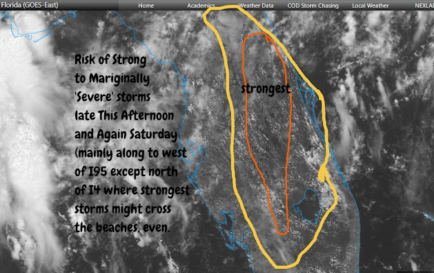
For today, as shown in the graphic above, there could be some very strongly active storms mainly WEST of I95 with a very slow steering eastward. There might be some storms that will manage to form even well after dark, but we'll see.
Do note that today is the 'transition' day so any storms to actually REACH the immediate east coast might be hard to come by (except for Volusia County mainly ... after dark there might be some activity if even light rain that 'could' reach Central Brevard Beaches, but no bets on that. The prime threat could be small hail and stronger wind gusts (non-severe/damaging) and of course, LIGHTNING.
SATURDAY: Saturday will be similar to today as it now appears but we will be already in 'full-transition' mode , meaning that the steering will already be in place at day break. That means the east coast and west coast sea breeze merger 'should theoretically' take place closer to the East Coast than it will today. Temperatures aloft will again be rather 'cold' so again, stronger storms possible after 4-5pm.
SUNDAY AND BEYOND: In general, temperatures aloft will warm a bit going into early next week so storm strength won't be 'as big' as a threat, though LIGHTNING will continue to be the ever-present and most lethal danger. Storms are not warned for Graphic and Intense LIGHTNING, so be fore-warned, as it is also the Number 1 killer in any Florida thunderstorm, and we could be seeing a lot of lightning across North Central - Central - and South Central Florida over the East Half of the Peninsula in days to come.
WRAP-UP: In general, though each day will have its variations, it now appears that we could be looking at storms favoring the East Half of the state for a solid week if not longer.
We might even get to the point where the east coast sea breeze will barely if at all form. On those days, storms will be harder to come by (moisture or no moisture makes no difference), as we need to have boundary collisions to generate a 'good storm' and temperatures on those days will SOAR.
ALSO - there is no way of knowing far out how much moisture will actually be available in the atmosphere. DOUBLE ALSO - the factor of cloud cover. If we have days were there is too much high or mid-level cloud cover in the first half of the day then storm coverage is greatly diminished.
FINAL COMMENT: Lightning is a very clear and present danger toward the East Coast for the next 7-10 days. Gusty winds, though not lethal could accompany some of the storms, and with slower storm motion areas prone to localized poor drainage could be problematic, especially if such an area receives a number of storms over consecutive days. If we have some days later next week when the sea breeze can't form at all or forms late, then the Heat Index will be another factor to consider.


No comments:
Post a Comment