
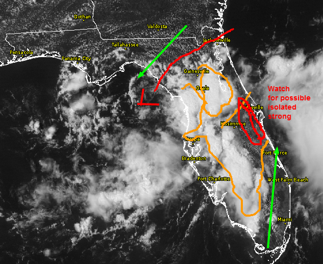
Quick post today due to time factor . Area of showers and thunder is approaching The Center of the state in the midst of on-going activity as noted above. The area in South Central is moving NE-ENE and heading toward a CAPE gradient boundary aligned from near and east of Kissimmee or mostly the entire east half of Osceola County, Eastern Orange, and Seminole with a direction poised toward the coast where instability drops off due to earlier cloud cover. Models were in zero agreement today for the most part as a low in the NE Gulf almost down to the surface moves little (appears that way). Mid-level winds are from the SW-WSW over-riding low level SE winds right in the high CAPE zone, so a sudden eruption "Could" occur in the western most red zone in the next 90 minutes or so. Much will depend on if the activity collapses or loses upper level support, as it seems to be getting triggered by something aloft such as a vorticity lobe not shown in guidance. Thus, areas from mostly of Orange, Seminole. Osceola Brevard, and parts of Volusia might need to have a heads up alert in the next two hours or so. If the area holds up, might need a renegade warning or two..OR..it fizzles to mere rainshowers.
TUESDAY: So far, good consistency up to now for an interesting day taking shape mainly for the East 1/2 of South Central from Melbourne down to Ft Pierce including the Vero area mid-late afternoon.
BEYOND: Much drier, most activity along I-10. Also, much warmer at the coast before the sea breeze, possibly hazy with an isolated late day or early evening sea breeze collision type "something or other storm" near or east of I-95. Low rain chances into the weekend .
No comments:
Post a Comment